TSX:CGD.V
Last:
Volume:
Change:
Date:
Time:
15-20 min delay
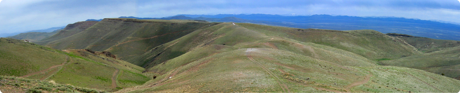


Eureka County, Nevada
Carlin Gold’s Cortez Summit property is located in the Cortez gold trend. The 100% owned property consists of 142 unpatented lode claims located in an area which hosts many gold deposits which have been mined in the past, currently in production or being explored to expand resources. The company’s primary target is Carlin-style mineralization in a structural and stratigraphic setting similar to that at the nearby deposits, including the Nevada Gold Mines’ (NGM, owned 61.5% Barrick Gold/38.5% Newmont Mining) Goldrush reserve/resource which is under mine development and the operating Cortez Hills mine. The southwest corner of the Cortez Summit property lies within 1.1 Km. northeast of the Goldrush deposit.
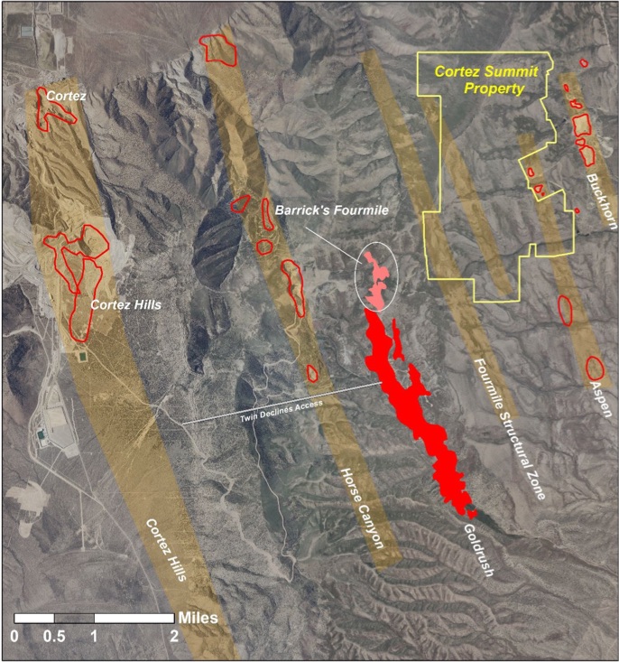
The Goldrush deposit is hosted primarily in a favorable interval in the Devonian Wenban Formation, a carbonate unit that is also an ore host to other deposits in the Cortez trend. Carbonates in the overlying Horse Canyon Formation are also hosts at Goldrush and in some of the other deposits in this district. The geographical and structural relationships of the mineralized trends are illustrated in Figures 1 and 2. Diamond drilling in 2013 by Carlin from a prior reverse circulation hole established that the sedimentary rock units at Cortez Summit are stratigraphically equivalent to the mineralized host units at Goldrush. The presence of favorable mineralized host rock stratigraphy in the vicinity of the important Fourmile structural zone combined with the property’s stratigraphic setting make Cortez Summit an excellent exploration target. Exploration potential has been amplified by the high grade holes in Barrick Gold’s “Fourmile”* discovery north of the Goldrush deposit and located adjacent to Cortez Summit (Figs. 1-4). Barrick states that these holes have encountered mineralization “well above the average grade of the indicated and inferred resources at Goldrush”, for example 14.3 meters(m) grading 31.7 grams per tonne (gpt) and 5.8m grading 49.6 gpt (Barrick Feb. 22, 2016 news release). Additonal results include 16.6m grading 71.6 gpt and 16.8m grading 57.9 gpt (Barrick July 26, 2018 webcast). Barrick’s Fourmile may represent a different mineralization style than at Goldrush. Although it is still contained in similar lower plate stratigraphic units, it is within the contact metamorphic zone adjacent to the Mill Canyon stock (see Fig. 3). Barrick points out similarities in mineralization style to the Deep Star and Deep Post deposits on the Carlin Trend (Barrick Investor Day webcast presentation, Feb. 22, 2016). Newly encountered high grade mineralization within the contact metamorphic zone is a positive development because this contact zone is present on Cortez Summit and presents a high grade target type.
The Goldrush indicated resource as of December 31, 2019, was 6.6 million oz grading 7.8 gpt with an inferred resource of 1.2 million oz grading 7.6 gpt, for a total indicated/inferred resource of 7.8 million oz attributable to Barrick’s 61.5% ownership (Barrick 2019 annual report) of the 12.7 million oz resource. A stand-alone underground feasibility study for Goldrush was submitted in Q2 2021 (Barrick Q3 2021 report) and the first bulk sample trial was successfully processed through the Goldstrike roaster. The Notice of Availability briefing package was published in the Federal Register in June 2022, triggering the public comment period of the Draft Environmental Impact Statement. A Record of Decision is expected in the first half of 2023 (Barrick Q2 2022 MD&A).
The Fourmile resource, located directly north of Goldrush, is owned 100% by Barrick and contains an indicated and inferred resource containing 2.55 M oz Au grading 10.6 gpt Au (Barrick 2021 annual report). Exploration drilling carried out in early 2022 shows strong evidence that the mineralized system extends three kilometers north of the current Fourmile resource (Barrick Q2 2022 MD&A).
The reported data from nearby deposits are for the information of the reader and are not necessarily representative of mineralization on Cortez Summit.
*Barrick’s “Fourmile” discovery is distinct from Carlin’s Fourmile Structural Zone referred to below and on Figures 2.-4
Figure 1 - Cortez Trend
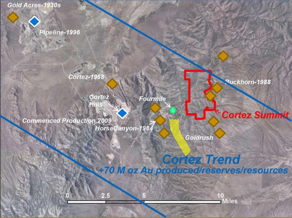
Figure 2 – Central Cortez Trend Structural Setting (Goldrush, Fourmile footprints – Barrick Gold 2021 Annual Report)
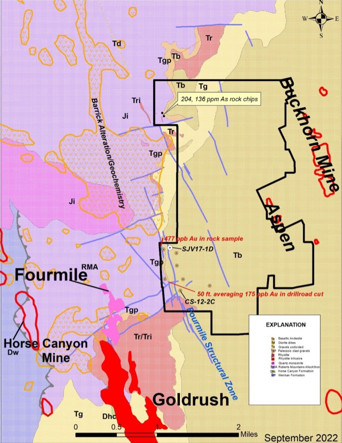
Carlin Gold identified the area as prospective and staked initial claims in 2007, prior to Barrick’s September 2011 announcement of the Goldrush discovery. The company was encouraged by initial rock sample geochemistry results from silicified and iron-stained siltstones from the NNW trending Fourmile structural zone on the west edge of the property. Grab samples collected from this area contained up to 0.447 gpt gold (Fig 4).
Two types of mineralizing systems exist on or adjacent to the Cortez Summit property:
Except for a narrow sliver of Paleozoic ‘Upper Plate’ siliciclastic rocks of the Ordovician Vinini Formation poorly exposed on the west edge of the property, the Cortez Summit property is covered by Miocene-age basalts and gravels which postdate the Carlin-style mineralization event. On the west side of the property, the Vinini Formation is unconformably overlain by a Tertiary volcano-sedimentary sequence consisting of a lower gravel unit and an upper series of Miocene (15-16 Ma) basaltic andesite flows. Drilling by Carlin Gold indicates that the Miocene sequence varies in thickness from zero on the west side of the property to >1,000 ft. (305 m) in the south central portion. The Buckhorn deposits are primarily hosted by basaltic andesite in this sequence. Dikes, plugs and minor flows of Miocene rhyolite locally intrude and overlie the gravel and basaltic andesite units, including the rhyolite plug exposed in the southwest corner of the property (Fig. 4, geology map).
Two intrusive phases are recognized just west of the property including: 1) Jurassic-age quartz monzonite of the Mill Canyon stock; and 2) probable Tertiary-age quartz porphyry dikes and small intrusive bodies. These quartz porphyry intrusions may be correlative with early Oligocene quartz porphyry dikes which are common at the Horse Canyon, Cortez Hills and other Cortez district deposits.
Two structural orientations dominate the Cortez Summit area: 1) NNW horst and graben structures that define the Northern Nevada Rift structural trend and control mineralization along the Aspen and Buckhorn mineralized zones, and 2) less well-defined NE-trending structures exhibited by the drainage patterns eroding the basaltic andesite (ie. Willow Creek structure). The Northern Nevada Rift structures associated with Buckhorn-style mineralization potentially represent shallow manifestations of reactivated deep-seated feeder structures involved in older Carlin-style mineralization at depth. A good example of this is the prominent NNW trending Fourmile structural zone that extendsfor 4,500 feet (1370 m) along the west side of the property and appears to be associated with Carlin-style alteration and geochemistry. Barrick has mapped alteration in upper plate units along the northern extension of the Fourmile structural zone off the Cortez Summit property and along Fourmile Canyon to the Crescent Valley range front, a distance of approximately 4 miles (6.4 km) (Fig. 5). This alteration zone abuts the post-mineral Tertiary conglomerate and Miocene volcanic rocks along the west side of the Cortez Summit property.
In August 2012 a reverse circulation drill program was initiated to establish the presence and depth of the favorable Lower Plate carbonate section on the west side of the property in proximity to the Fourmile structural zone. Most of this target area is covered by post-mineral gravel and basaltic andesite. Where Paleozoic rocks are exposed on the west edge of the property, sampling along the Fourmile structural zone has yielded gold values of 0.447 and 0.263 gpt in altered siliciclastic rocks. Rock sampling along a drill road cut yielded 0.175 gpt gold over 50 feet (15 m) in altered siltstones (Fig. 4).
Figure 3 – Activity Adjacent to Cortez Summit Property
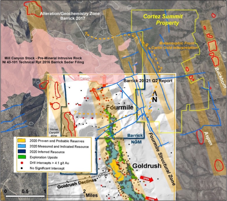
Figure 4 – Cortez Summit Geology
Exploration Drilling
Seven (7) reverse circulation drill holes were completed in 2012 to depths ranging between 1500 and 1800 feet (457-549 m), for a total of 11,720 feet (3,573 m). All holes encountered upper plate Paleozoic sedimentary rocks. One hole was collared in the Paleozoic rocks and the remainder were drilled into Paleozoic rocks beneath younger Miocene basalts and gravels. Paleozoic lithologies include grey-black siltstone, with lesser sandstone and chert. CS12-7 penetrated and bottomed in a 300 foot interval containing variably laminated calcareous siltstones.
Anomalous gold, 0.101 to 0.267 gpt, with Carlin-type pathfinder elements are present in six of the seven holes drilled in 2012. Anomalous arsenic zones (>100 ppm) range up to 115 feet (35 m) in drilled thickness and contain values up to 1,530 ppm arsenic, 70 ppm antimony, 3 ppm thallium and 1.8 ppm mercury. Two holes with the longest anomalous arsenic intervals (CS12-1, 3) were drilled 1,900 feet (580 m) apart on the west side of the property, and are located in close proximity to the Fourmile structural zone. These intervals occur in the upper plate strata above the lower plate Horse Canyon and Wenban formations encountered in the drilling described below.
In September 2013 the company re-entered vertical reverse circulation hole CS12-2 with a diamond drill which deepened it from 1,760 ft. (537 m) to 4,032 ft. (1,229 m). This site was chosen in part because it appears to be located at the inferred intersection between the NE-trending Willow Creek structure and the NNW-trending Fourmile structural zone. Short intervals of anomalous gold values to 0.667 gpt and Carlin-type pathfinder elements were encountered in hole CS12-2C, including intervals of anomalous arsenic values (>100 ppm) ranging up to 85 ft. (25 m) of drilled thickness. The bottom 392 (120 m) consisted of silty/sandy, laminated, variably carbonaceous limestone, interpreted to be lower plate strata of the Horse Canyon and Wenban (?) formations. This material locally displays Carlin-type alteration features such as decalcification, clay alteration and calcite veining. Carlin geologists are encouraged that favorable lower plate altered carbonate rocks are present near the projection of the Fourmile structural corridor.
In November 2016 the Company announced signing of an Exploration and Earn-In agreement with Barrick Gold Exploration Inc. on the Cortez Summit property (see news releases on this site). Barrick completed a 5,171 ft. (1,576 m) vertical core hole, SJV17-1D, in May- July 2017, located along the east side of the Fourmile structural corridor in the vicinity of Carlin’s shallow holes drilled in 2012 (Fig. 4). SJV17-1D encountered a long 567 ft. (173 m) zone at 333-900 ft. (102-274 m) in upper plate rocks consisting of variably clay-altered, iron oxide-stained, brecciated hornfels and lesser mudstone/siltstone, with the most intense clay alteration and iron oxide development at 652-798 ft. (199-243 m). Associated with this alteration is a very thick interval, 592 ft. (180 m), of highly anomalous arsenic at 328-920 ft. (100-280 m) averaging 480 ppm, with accompanying additional strongly anomalous Carlin-style pathfinder elements including mercury (to 17 ppm), antimony (to 173 ppm) and thallium (to 6.3 ppm). Gold values in this alteration zone include a 10 ft. (3 m) zone at 694-704 ft. (211-214 m) grading 2.6 gpt. The favorable lower plate carbonate section was encountered at a depth of 4,234 ft. (1,290 m), although no significant gold values were detected. After completing this one hole, Barrick terminated the Exploration and Earn-In agreement in 2018.
The Company is encouraged by the strong alteration and pathfinder elements along with elevated gold values encountered in upper plate rocks adjacent to the Fourmile structural zone. The geometry of this “shallow” altered and geochemically anomalous zone has not been defined. It potentially represents the upper level of a mineralized structural conduit, which could be used as a guide to deeper gold mineralization in lower plate carbonate rocks. A shallower, ±200 ft. (60m drilled thickness) silty to sandy carbonate section contained within the upper plate sequence was encountered by SJV17-1D and in one of the early Carlin drill holes (CS-7) located 2,200 ft. (670m) south-southeast. This represents an additional potentially significant host rock target, approximately 2,000 ft. (610 m) above the base of the Roberts Mountain Thrust.
The property has only been partially explored, as drilling to date has tested just a small portion of the ground in the southwest corner of the 4 square mile claim block. SJV17-1D is the only drillhole to have fully penetrated the favorable lower plate section that hosts the nearby Goldrush reserve/resource and Fourmile indicated and inferred resources. Hornfels alteration in upper plate rocks has been encountered in most of the holes drilled to date, which is likely produced by the thermal effects of the nearby Jurassic age Mill Canyon quartz monzonite stock. The thermal contact zone around this stock is an important geological control of the high-grade mineralization encountered at Barrick’s Fourmile resource. This contact metamorphic environment is present on Cortez Summit, suggesting that in addition to the classic Carlin-type bedding replacement style mineralization displayed at Goldrush, the property also has excellent potential for higher grade, more structurally controlled mineralization within the contact aureole of the Mill Creek stock.
Carlin Gold has evaluated existing ground and airborne geophysical survey data which has been helpful in better defining the Fourmile structural zone and also in identifying several other structures on the property. The geophysical information suggests the continuation of the Fourmile structural zone at depth below the post-mineral cover. The Fourmile structuralzone represents a high -quality target for classic Carlin-style mineralization where it intersects the favorable lower plate carbonate stratigraphy. The available geological and geophysical information suggests that several additional prospective northwest-trending structures are located parallel to and east of the Fourmile structural zone. Carlin Gold geologists are encouraged by the exploration opportunities represented by these additional targets.